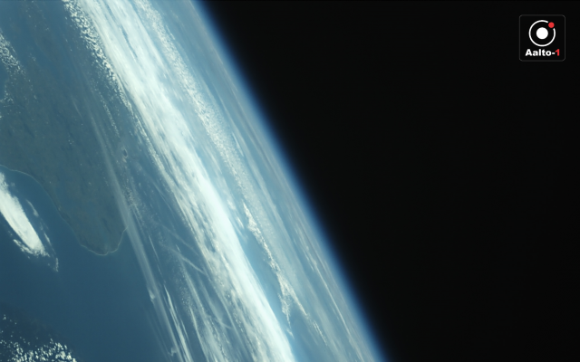
The photograph was taken with the VTT Technical Research Centre of Finland developed hyperspectral camera’s secondary camera.
Launched on the morning of 23 June from India, the Aalto-1 satellite’s first month in space has gone according to plan.
‘We have run checks on the majority of the satellite’s systems and found that the devices are fully functional,’ Aalto University’s Professor Jaan Praks, who is heading the satellite project, explains.
‘We have also downloaded the first image sent by Aalto-1, which is also the first ever image taken from a Finnish satellite. It was taken while on orbit over Norway at an altitude of about 500 kilometres. The image shows the Danish coast as well as a portion of the Norwegian coastline.
The photograph was taken by the secondary camera for the VTT-developed hyperspectral camera. The secondary camera faces the same direction as the main hyperspectral camera, but it has a slightly broader view angle to support, the analysis of the hyperspectral camera’s images.
‘On the basis of this first image, the system works as planned. The main hyperspectral camera will be tested later this week,’ Research Scientist Antti Näsilä from VTT says.
Unlike traditional cameras, which measure three colours, the hyperspectral camera is able to measure dozens of freely selected narrow color channels. For this reason, it can be utilised for example in surveying forest types, algae and vegetation and as a tool in geological research.
The Aalto-1 satellite is also carrying a radiation monitor jointly constructed by the Universities of Helsinki and Turku and a Plasma Brake built by the Finnish Meteorological Institute. When the time comes, the brake will allow the satellite to slow down and fall into the Earth’s atmosphere where it will burn to dust, ensuring that it will not be left behind as space debris.
‘The plasma brake has naturally not been tested yet. However, we have used the radiation monitor to measure an area of high radiation called the South Atlantic Anomaly,’ Petri Niemelä Manager of the Otaniemi base station, which is overseeing the operations of the satellite, explains.
A year of measurements
Jaan Praks emphasises that although the functionality of the technology has been demonstrated, the satellite mission itself is only in its early stages. The plan is to collect data and images over the course of several months or even an entire year. The mission schedule also includes stabilising of the satellite’s attitude.
‘Until now, we have allowed the satellite to slowly tumble as this is ideal with regard to spacecraft temperature management. So far, the satellite’s internal temperature has remained wonderfully between zero and 25 Celsius for the duration of its mission, alternating according to whether the the satellite has been in shade or light.’
From Aalto University’s and Finland’s perspectives space research prospects are bright. Nanosatellites developed by numerous start-ups as well as a third Aalto satellite, i.e. the Suomi 100, are to be launched into space this year.
‘Finland now has the opportunity to register its first space device in the UN’s international Register of Objects Launched into Outer Space,’ Mr Praks notes.


